
Ortho Photo#
An orthophoto is a geometrically rectified image providing an orthographic view, where for each pixel the geolocation is known. Orthophotos are typically produced from satellite imagery or aerial photography (Orthophoto).
In weitsicht the orthophoto implementation is weitsicht.ImageOrtho and is based on
rasterio.
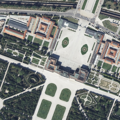
Orthophoto from Vienna showing parts of Schloss Schönbrunn.#
Geo-reference#
The geo-reference can be provided either:
as metadata in the file (e.g. GeoTIFF), or
as sidecar files (e.g.
.jgwfor a JPG world file).
In GDAL terminology this is the geotransform, an affine transformation from pixel space (row/column) to a geo-referenced coordinate space.
See World File for more background.
Warning
Currently only the affine transformation (GDAL geotransform / world file) is implemented for ortho photos. RPCs and GCP-based geo-referencing are not supported.
Coordinate Reference System#
The CRS of an orthophoto is usually stored as metadata (GeoTIFF) and can sometimes also be supplied by a .prj sidecar
file containing WKT.
Projected and geographic CRSs are supported. For more information see WKT.
Project (3D → pixels)#
To get the pixel location of a 2D/3D point, use ImageOrtho.project.
Coordinates are transformed to the orthophoto CRS (if needed).
The affine transform is inverted to map ground coordinates into pixel space.

Mapping (pixels → 3D)#
For orthophotos, mapping uses the orthophoto’s geotransform for XY and relies on the attached mapper (if any) to provide Z
via map_heights_from_coordinates.

GSD and area (resolution-based)#
Unlike perspective images, orthophotos are already rectified into an orthographic view. weitsicht therefore treats
their pixel size as constant and uses the dataset resolution (derived from the affine geo-transform):
mapping results set
gsdtoImageOrtho.resolutionand fillgsd_per_pointwith that constant value,map_footprintcomputesareafrom the mapped footprint polygon in the orthophoto CRS.
Warning
resolution, gsd, and the computed polygon area are expressed in the orthophoto CRS units. If the orthophoto
CRS is geographic (lon/lat degrees) or otherwise non-metric, these values are degrees/pixel and degrees^2 (or other
non-metric units) and are not meaningful physical measurements. Reproject the orthophoto to a projected metric CRS
(meters) before using GSD/area for measurement workflows.