
05-01 - OrthoImagery#
The following example demonstrates how to work with geo-referenced orthophoto imagery:
map the center point (samples height via a mapper),
map the footprint (corners and densified edges),
project world coordinates into orthophoto pixels and map them back to 3D.
Import Modules#
from pathlib import Path

import numpy as np
import pyproj.network
from pyproj import CRS

from weitsicht import ImageOrtho, MappingRaster

# Example data is stored under tests/data (shared with unit tests)
DATA_DIR = Path(__file__).parent.parent.resolve() / "tests" / "data"
PYPROJ#
# In that example we have different CRS systems of the image pose and the mapper
# and therefore we need to activate the network capabilities of pyproj to get the needed grids for transformation
pyproj.network.set_network_enabled(True)  # pyright: ignore[reportPrivateImportUsage]
Initialize Image class#
# Load orthophoto from file
image = ImageOrtho.from_file(DATA_DIR / "44_2_op_2023_30cm.tif", crs=CRS("EPSG:31256+5778"))
if image is None:
    raise RuntimeError("Failed to load orthophoto")

# CRS is MGI Gauss Krueger M34
print("CRS: ", image.crs_wkt)
print(f"Resolution: {image.resolution:2.4f}")
Initialize Mapper class#
# In this example we assign the mapper to the image after the image is already initialized.
# The DTM raster values are given in Vienna Heights (EPSG:8881)

# Load raster file for Mapper
image.mapper = MappingRaster(DATA_DIR / "44_2_dgm.tif", crs=CRS("EPSG:31256+8881"))
Map center point#
result_center = image.map_center_point()
if result_center.ok is True:
    print("\nMapped center point:", result_center.coordinates)
    print(f"GSD at center pixel: {result_center.gsd:2.3f}")
    print("Normal (center):", result_center.normals[result_center.mask])
    if result_center.gsd_per_point is not None:
        print("GSD per point:", result_center.gsd_per_point[result_center.mask])
else:
    raise RuntimeError(f"Mapping center point failed: {result_center.error} ({result_center.issues})")
Map footprint#
result_footprint = image.map_footprint()
if result_footprint.ok is True:
    print("\nMapped footprint (corners):", result_footprint.coordinates)
    print(f"Area: {result_footprint.area:2.0f}")
    print(f"GSD:  {result_footprint.gsd:2.3f}")
    print("Normals:", result_footprint.normals)
    if result_footprint.gsd_per_point is not None:
        print("GSD per point:", result_footprint.gsd_per_point)
else:
    raise RuntimeError(f"Mapping footprint failed: {result_footprint.error} ({result_footprint.issues})")
Densify footprint edges#
result_footprint_dense = image.map_footprint(points_per_edge=5)
if result_footprint_dense.ok is True:
    print("\nMapped footprint (densified):", result_footprint_dense.coordinates)
    print("Number of points:", result_footprint_dense.coordinates.shape[0])
    print(f"Area: {result_footprint_dense.area:2.0f}")
    print(f"GSD:  {result_footprint_dense.gsd:2.3f}")
    print("Normals:", result_footprint_dense.normals)
    if result_footprint_dense.gsd_per_point is not None:
        print("GSD per point:", result_footprint_dense.gsd_per_point)
else:
    raise RuntimeError(
        f"Mapping densified footprint failed: {result_footprint_dense.error} ({result_footprint_dense.issues})"
    )
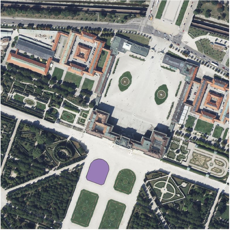
Project and map points roundtrip#
# Coordinates are in the orthophoto CRS (x/y).
garden = np.array(
    [
        [-1563.025, 338413.602],
        [-1560.834, 338407.607],
        [-1529.935, 338396.308],
        [-1524.170, 338398.614],
        [-1512.756, 338429.859],
        [-1513.563, 338438.737],
        [-1518.636, 338447.038],
        [-1526.245, 338452.226],
        [-1535.700, 338453.725],
        [-1546.191, 338450.612],
        [-1552.763, 338443.694],
        [-1563.025, 338413.602],
    ]
)

garden_3d = np.column_stack((garden, np.zeros((garden.shape[0], 1), dtype=garden.dtype)))

result_proj = image.project(garden_3d, crs_s=image.crs)
if result_proj.ok is True:
    print("\nGarden projected into orthophoto pixels:", result_proj.pixels)
    if result_proj.issues:
        print("Projection issues:", result_proj.issues)
else:
    raise RuntimeError(f"Projecting garden coordinates failed: {result_proj.error} ({result_proj.issues})")

result_map = image.map_points(result_proj.pixels)
if result_map.ok is True:
    print("\nGarden mapped from projected pixels (with heights):", result_map.coordinates)
    print(f"Mean GSD: {result_map.gsd:2.3f}")
    print("Normals:", result_map.normals)
    if result_map.gsd_per_point is not None:
        print("GSD per point:", result_map.gsd_per_point)
else:
    raise RuntimeError(f"Mapping projected garden pixels failed: {result_map.error} ({result_map.issues})")
Checks#
np.testing.assert_almost_equal(result_map.coordinates[:, :2], garden[:, :2])